Tripoli Security Directorate and the Libyan Center for Remote Sensing and Space Sciences discussed the necessary needs to prepare for any possibilities regarding earthquakes.
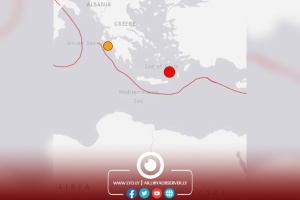
The Director of the Libyan Center for Remote Sensing and Space Sciences, Akram Al-Kaseh, revealed the details of last Thursday’s earthquakes in Houn and Al-Aziziya faults, saying that their approximate location was southwest of the city of Sirte, and northeast of the city of Wadan in the Houn fault, 90 kilometers from the Libyan coast, adding that the epicenter was not determined, but it had a magnitude of 4.8 on the Richter scale, and a depth of 230 kilometers, happening at 15:31.
Al-Kaseh indicated that the second earthquake occurred at 15:33 and its approximate location was in the Al-Garyat area in the Western Mountain on the Al-Aziziyah fault extending from Misrata in the east to beyond the Libyan-Tunisian-Algerian border. Its epicenter was not determined, and it had a magnitude of 4.2 on the Richter scale, and a depth of 10 kilometers.
He indicated that the second quake was a surface one, so it was felt by the residents of the city of Tripoli and Qasr Bin Ghashir, and it occurred as a result of the first one.
According to the Tripoli Security Directorate, the meeting urged for the need to monitor geological indicators and the necessity of taking preventive measures and preparing for any emergency after the two minor earthquakes that took place in west Libya last Thursday, leaving no casualties or material damage.